The Inuit meaning of inukshuk is “in the likeness of a human”. Used as a communication beacon in traditional times, these unworked stones compiled in rough human form signaled to others that someone had been there or that followers were on the right path. These landmarks also were built to mark a place of respect or as memorials for loved ones. Churchill has some impressive inukshuks around the area that travelers gravitate to and often photograph in daytime or with dynamic northern lights in the sky over the Hudson Bay.
Northern lights over the Hudson Bay behind the Inukshuk in Churchill. Sean Beckett photo.
Hunters utilize them by marking migration paths or near water where fish are plentiful. Sometimes in these cases, inuksuit are arranged in sequences over short or long distances to better signify the trail. Spiritual meanings have also been associated with these stone sculptures by Inuit peoples. These rock forms are of the oldest and most iconic objects bonding the Arctic with the Inuit people and culture of the north. Inuit tradition does not allow the destruction of inuksuit as they are often thought of as symbolizing ancestors that learned the ways of surviving on the land.
In a land of vast emptiness and barren landscape, a familiar inukshuk is a welcome sight to a traveler on a featureless and forbidding landscape.
An inukshuk can be small or large, a single rock, several rocks balanced on each other, round boulders or flat. Built from whatever stones are at hand, each one is unique. The arrangement of stones indicates the purpose of the marker. The directions of arms or legs could indicate the direction of an open channel for navigation, or a valley for passage through the mountains. An inukshuk without arms, or with antlers affixed to it, would act as a marker for a cache of food.
The Inukshuk was the basis of the 2010 Winter Olympics logo designed by Vancouver artist Elena Rivera MacGregor. The form also is featured as the centerpiece of the colorful flag of Nunuvut, the homeland of the Inuit.
The view and expanse of the land from a helicopter gives one a completely different perspective. The boreal forest stands alone from the wide open tundra and the Hudson Bay goes on forever to the north. I never tire of seeing the landmarks as well as the land from the air. Enjoy these photographs of the Churchill region!
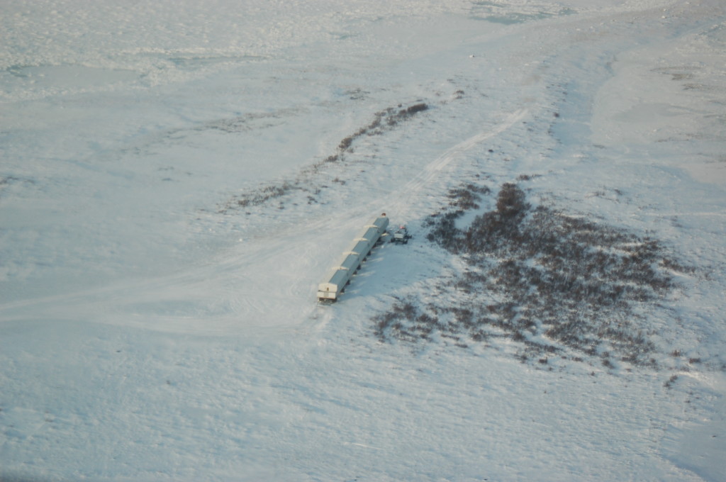
Natural Habitat Tundra lodge. Steve Selden photo.
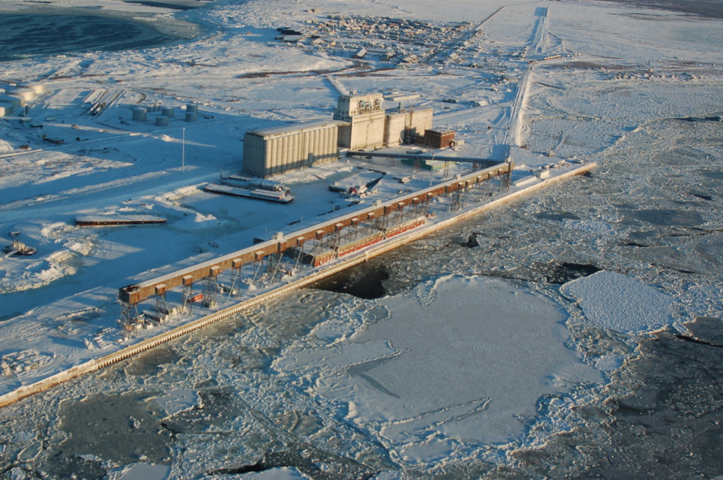
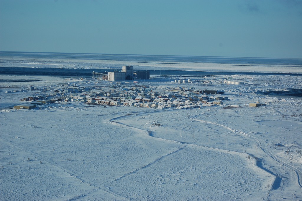
Port of Churchill on the Churchill River. Photo Steve Selden
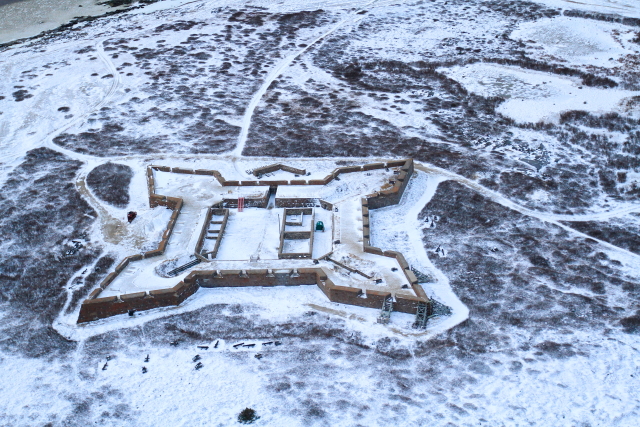
Fort Prince of Wales on the West side of the Churchill River. Steve Selden photo.
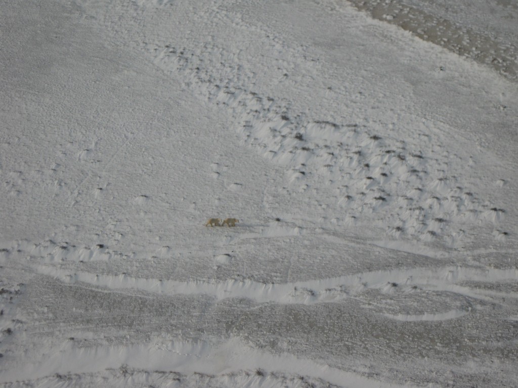
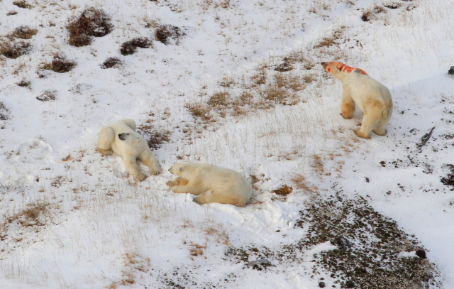
Two polar bears near the coast in November. Karen Walker photo.
Polar bears along the Hudson Bay coast. Natural Habitat Adventures photo.
A view through Churchill, to the port and north over the Hudson Bay. Natural Habitat Adventures photo.
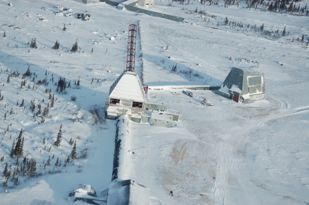
A closer look at the Churchill Rocket Range today. Steve Selden photo.
These fresh images from Churchillian Katie DeMeulles reveal just a glimpse of Spring in Churchill. The main clue is the ice floe edge is fairly close to shore and the open water lead is widening. Of course that could close up again with some north winds but spring is imminent. It’s such an amazing time of year in Churchill!
Willow ptarmigan in the willows. Katie de Meulles photo.
The ice floe edge is closer to shore. Katie de Meulles photo.
Willow ptarmigan camouflaged in the grass. Katie de Meulles photo.
The ice floe edge is close to the rocky shore of Churchill. Katie de Meulles photo.
The Ithaca shipwreck still frozen in the Hudson Bay. Katie de Meulles photo.
Ptarmigan on the Precambrian shield in Churchill. Katie de Meulles photo.
This photograph from a helicopter over Wapusk National Park is a tremendous look at a polar bear den. Sheltered in a stand of spruce trees to break the wind, this is the ideal spot for a sow polar bear to have cubs. This den will be used every year for an extended period. Wapusk is the prime destination for polar bears to actively den and have cubs.
Polar bear den in a stand of spruce trees. Courtesy Natural Habitat Adventures photo.
Dene Village in Churchill is a forlorn place for the most part. There is a stone monument just off Goose Creek Road as you pull off into the vacant, silent,raised subdivision commemorating the 150 Dene people that died following their forced relocation by the government from the north country.
Back then was the beginning of the end for the Dene. They were living off the land as native people did when the Canadian government decided they were in need of “civilization”. Unfortunately “civilization” was not what the Dene needed nor wanted at the time and their endless shuffling from place to place around Churchill began.
The Dene relocation story will be explored in subsequent posts as this post is about what we discovered in the patch of forest adjacent to the village back in the days of guiding Churchill Arctic summer trips.
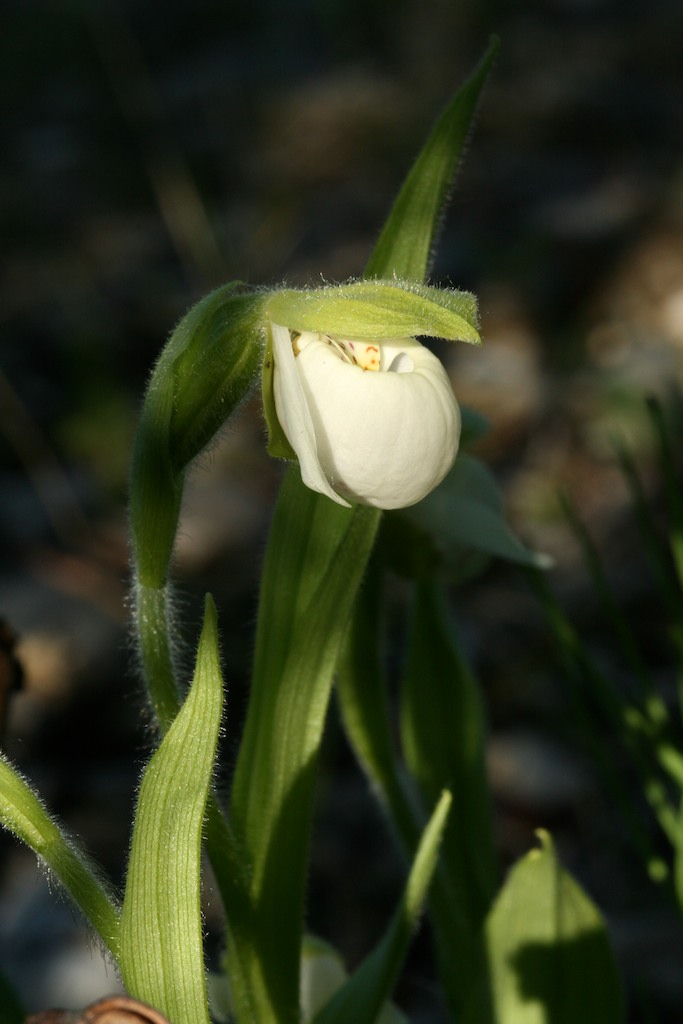
Round leaved orchid. Courtesy wikidmedia.org.
I don’t know how we came upon the majestic trove of incredible orchids hidden in the boreal forest just behind some of the burned or raised cottage foundations in the village but we did. With all the buildings gone as you meander through the sub-division, one goes from an erie feeling of trespassing on sacred ground to an amazing short walk through the forest with about five or six different stops to examine and photograph various orchids found in Churchill.
Hodded Lady’s – Tresses. Shelly Weedmark photo.
The orchids we found and returned time after time with groups to see in this sacred place were Hooded Lady’s – Tresses, Small Northern Bog Orchid, Round – leaved Orchid, Northern Lady’s – Slipper, Green Flowered Bog Orchid and Early Coralroot. When we would walk quietly through the soft grounded undercover of this particular spot I remember telling the people I felt like these beautiful orchids were the souls of the Dene people that had suffered and died in Churchill. That they were back in another form and that new reincarnated form was brought forth in these incredible flowers. That the pain the people had gone through was now somehow released and become beauty in the world.
I still think of these walks we took and I feel lucky to have had these experiences. The feelings from the powerful orchids….souls of the world are still with me today.
The Churchill Rocket Range at Fort Churchill has been an integral part of Canadian rocket research within the sub – orbital atmosphere. Located just east of Churchill, the site has been used since the 1950’s for multiple launches of various rockets such as the Nike-Orion and Black Brant. Closed today, the range has gone through many transitions over the years.
Black Brant rocket at the Churchill rocket Range. Courtesy Natural Habitat
Churchill’s unique proximity in the “western hemisphere” coupled with its wide open range firing northwards made it optimal not only for incredible polar bear viewing but for rocket launching as well. Test rockets are still being discovered today in the vast, wide open tundra.
1. – The rocket range was built in 1954 by the Canadian Army to study long distance communication capabilities and the affects the aurora borealis has on them.
2. – The site was closed in 1955 then reopened and refurbished and expanded in 1956 for the International Geophysical Year (IGY) in 1957. The site was then closed again in December 1958 when the IGY ended.
3. – In 1959 the U. S. Army reopened the rocket range as a sounding rocket test station. It was used to test rockets which evolved into the Black Brant utilizing new solid fuel propellant. Fire destroyed much of the facility in 1960 and 12 additional test launches of the black Brant were scheduled at NASA’s Wallops Island in 1961-62 while the Churchill site was rebuilt. In 1970 the U. S. Army ended operations at the site.
Churchill rocket range from the air. Steve Selden photo.
4. – In 1970 the Churchill site was acquired by the Canadian Research Council to contribute to the Canadian Upper Atmosphere Research Program. The range was used intermittently during the 70’s and 80’s and shut down by 1990.
5. – Rumors surfaced in the mid 1990’s when Akjuit Aerospace announced development of the site aat a $300 million price tag was imminent. A Russian company named STC Complex signed a deal with Akjuit to launch polar – orbiting rockets carrying loads on surplus, re-purposed ICBM’s as part of the START treaty negotiations. In May 1998 Akjuit Aerospace closed down operations from financing problems as well as the collapse of the space exploration market in 2000.
A closer look at the Churchill Rocket Range today. Steve Selden photo.
Today the Churchill Rocket Range stands as a reminder of the frenetic past in Churchill as well as what might have been had Akjuit launched the ambitious new venture at the site. The buildings near the Churchill Northern Studies Center seem frozen in time, suspended in anticipation of what the future could have been.