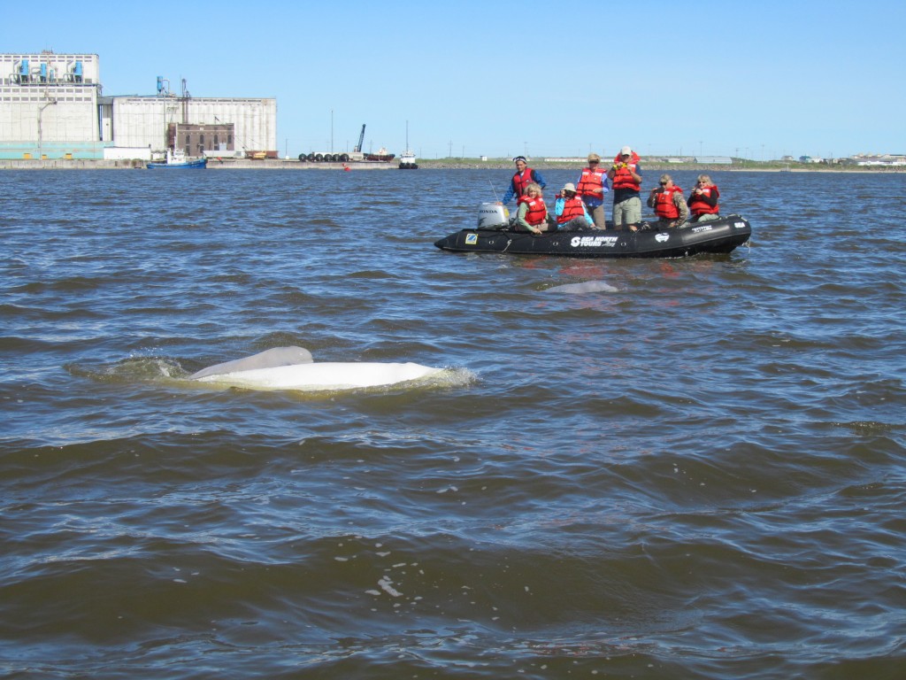
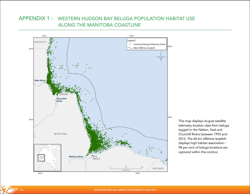
Nearly a quarter, 57,000, of the worlds beluga population estimated at 200,000 migrate to the Western Hudson Bay estuaries of the Seal, Nelson and Churchill Rivers. The province of Manitoba is hoping the liberal government keeps promises made during the 2015 election to protect five per cent of Canada’s more than 200,000 kilometer coastline by 2017 and include this region. Manitoba government is pushing hard for protection of these estuaries as part of their new Beluga Habitat Sustainability Plan.If the plan goes through and is implemented it would protect moulting, feeding and calving areas for the nearly 60,000 belugas along the Hudson Bay coast in the Churchill region. This area comprises the largest sub – population in the world …a quite healthy population indeed. Nearly half the other populations, including the St. Lawrence River group in eastern Canada, are not doing as well. Increased development has deployed carcinogens through harmful chemicals into these waters.The proposal from Manitoba province will also include requests to amend federal legislation regulating pollution in Arctic waters south of the 60 degrees lattitiude so to cover the fragile ecosysystems in the estuaries frequented by the belugas. Although the current status of these creatures is healthy, rapid change in the Arctic could affect the species adversely in the near future.Development along the rivers directly related to reduced ice formation in the Arctic was listed as potential threat to the belugas of Manitoba. The difference between these river sanctuaries and the St. Lawrence where massive development has caused negative effects and subsequent “threatened” classification of that beluga whale population is vast. However a future change in commerce due to global warming could change things for Hudson Bay belugas in a hurry.A direct consequence of arctic ice melt would be increased shipping leading to extensive noise pollution that would harm the belugas ability to echo-locate and communicate with one another. Warming trends also have implications on the beluga’s winter feeding grounds in the Hudson Strait in the northeast. The ice harbors algae that sustain fish that belugas prey upon as well serving as a safe haven for the belugas hiding from killer whales. These predators are quite common in the bay in recent years due to more access from longer ice free periods.A key consideration in Churchill, and more specifically the Churchill River, is the long term strategy of the Port of Churchill, currently in the process of changing ownership. The relationship and interactions between the port and the belugas to date have been very good. With new owners and possible new directions in shipping from the facility it is important to cover all the angles with regards to water contamination and shipping routes and frequency.
With belugas coming to Churchill each summer there has been an increase in tourism as a result. The economic benefits from this would be adversely affected if protection was not placed on the estuary.
Beluga whale watching near the port of Churchill. Natural Habitat photo
Because of these current and impending threats, advocates and researchers are intent on protecting the clean estuaries now before the need becomes dire. Once development ensues to a higher degree as a result of environmental change it could be too late Thinking ahead and protecting these areas now is crucial!
Fortunately the “last ice” region we are discussing is being used in a manner of symbolism. The area of interest is above Canada’s High Arctic Islands and northwest Greenland. National Geographic Society and World Wildlife Fund-Canada are on a mission to protect the Arctic.
Since the late 1970s when satellite monitoring was instituted, Arctic summer sea ice extent has been shrinking at a rate of about 12 per cent per decade, according to both organizations in an August news release.
Polar bear on sea ice in the high Arctic. Natural Habitat Photo.
The two organizations have teamed up to increase attention and awareness of — the “Last Ice Area” — the region climate scientists project summer sea ice to last the longest.
Recognizing the ‘Last Ice Area’ and the need to protect it for ice-dependent species and northern communities has been a top priority of our Arctic work for several years,” said WWF-Canada President and CEO David Miller. “We couldn’t have asked for a better partner to help steer the public eye northward to this important region.”
The National Geographic Pristine Seas project will include partner WWF-Canada to bring attention to the threats facing the summer sea ice and document “how the Inuit culture is connected to the area and its extraordinary wildlife.”
The “last ice area” near Greenland. Jane George photo.
“Highlighting the ‘Last Ice Area’ and the need to protect it for ice-dependent species and northern communities has been a top priority of our Arctic work for several years,” said WWF-Canada President and CEO David Miller. “We couldn’t have asked for a better partner to help steer the public eye northward to this important region.”
The Pristine Seas project by National Geographic will partner with WWF-Canada to spread awareness of the threats of shrinking summer sea ice areas. The connection between the inuit culture of the north and the extraordinary wildlife will be the primary focus.
“We came close to Arctic wildlife and filmed them like never before while also documenting the last traditional hunting by the Inuit,” said National Geographic’s Enric Sala about a recent trip to northern Baffin Island.
Wildlife researcher and photographer Brent Stephenson recorded these images in Baffin Island in the far north of Canada. An incredible day around Baffin where a pod of over 100 narwhals followed his vessel around. Even some male narwhals with tusks breaking the water’s surface appeared. Around ten polar bears throughout the day provided constant thrills and photo opportunities. Later a gyrfalcon made a kill in front of the bow viewed through binoculars. What a day in the high Arctic!
Yesterday, in Churchill, Shelly Glover, Minister of Canadian Heritage and Official Languages and Minister responsible for Manitoba, along with Manitoba Premier Greg Selinger announced the future construction of $31.7 million marine research facility, the Churchill Marine Observatory, in Churchill. The facility will be located adjacent to the Port of Churchill which is Canada’s sole Arctic accessible deep-water port.
Officials in Churchill announcing plans for Churchill Marine Observatory. Town of Churchill photo.
Apparently the main focus of the Churchill Marine Observatory will be a facility for researchers to study discovery, impact and mitigation of oil spill disasters in sea ice regions within the northern Arctic and subarctic regions. The observatory will also study issues encompassing present and future Arctic marine transportation. Climate change and sea ice shifting has created new possibilities for shipping in the northern regions. Canada and specifically Churchill will be strategically positioned globally through ongoing study of the scientific and economic issues that pertain to Arctic marine transportation with regards to oil and gas exploration.
Researchers from major Canadian universities, University of Washington and Canadian federal government departments will come together through this new facility. Saltwater subpools and an environmental observing system constructed on the Churchill estuary will allow scientists to study actual conditions and complications of oil spills in Arctic seawater and sea ice. Overall, hopes the project will strengthen Canada’s capacity to protect the environment in the Arctic.
Sir John Franklin’s lost ship the Erebus was found this past year in Queen Maude Bay in the high Arctic and some of the ships artifacts have been collected and organized into an exhibit that will be on display at various venues throughout Canada over the next several months. The exhibit is currently open in Saskatoon, Saskatchewan and runs through July 5th.
A sneak preview of the Erebus exhibit; Echoes in the Ice – Finding Franklin’s Ship, a display of artifacts from the recent discovery. Kathy Fitzpatrick/CBC photo.
The exhibit mainly contains photos and videos of the discovery of the ship that was lost looking for the Northwest passage in 1845. In the years to come the exhibit surely will grow to contain many additional artifacts raised to the surface after they are carefully documented and mapped underwater. Speculation is abuzz that Churchill’s own “Lady Franklin” stained glass window that currently is displayed in the Anglican church in town might be included. John Franklin’s wife gave this to the 40 groups of searchers who looked for Franklin and his lost expedition over the years. The treasure was moved to Churchill from York Factory in 1967…apparently as lore has it in a barrel of molasses.
Close – up of the Lady Franklin stained glass window. Karen Walker photo.
Fascinating video of the wreck site has been collected this spring when ice still sealed the ocean surface and prevented any disruption of the silt from wave action.
The exhibit moves to Moose Jaw, and runs from July 5 to September 27. Following that time it will open in North Battleford and open in January.
 Development along the rivers directly related to reduced ice formation in the Arctic was listed as potential threat to the belugas of Manitoba. The difference between these river sanctuaries and the St. Lawrence where massive development has caused negative effects and subsequent “threatened” classification of that beluga whale population is vast. However a future change in commerce due to global warming could change things for Hudson Bay belugas in a hurry.A direct consequence of arctic ice melt would be increased shipping leading to extensive noise pollution that would harm the belugas ability to echo-locate and communicate with one another. Warming trends also have implications on the beluga’s winter feeding grounds in the Hudson Strait in the northeast. The ice harbors algae that sustain fish that belugas prey upon as well serving as a safe haven for the belugas hiding from killer whales. These predators are quite common in the bay in recent years due to more access from longer ice free periods.A key consideration in Churchill, and more specifically the Churchill River, is the long term strategy of the Port of Churchill, currently in the process of changing ownership. The relationship and interactions between the port and the belugas to date have been very good. With new owners and possible new directions in shipping from the facility it is important to cover all the angles with regards to water contamination and shipping routes and frequency.